Toeristische regiokaarten HONGARIJE
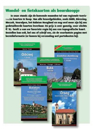
UITVERKOOP: Laatste diverse fiets- en wandelkaarten regio’s Hongarije. Nu voor € 5,- of 3 kaarten voor € 10,- (Maar de gele kaarten van Cartographia blijven € 10,-).
LET OP: Een overzicht van het totale aanbod staat hier (maar niet alles is meer leverbaar).
De kaarten zijn zolang de voorraad strekt ook te koop in onze stands op de Fiets- en wandelbeurs het tweejaarlijkse festival HungaroMania in Leuven (B), zie onze Belgische site) en op Hongarije Plaza (2021?).
Nieuw: kaart van de Dráva-fietsroute
De kaart biedt in meerdere deelkaarten een gedetailleerd overzicht van de Dráva en de fietspaden en wegen aan weerskanten van de Hongaars-Kroatische grensrivier van Murakeresztúr tot Osijek! Weer een stukje van de Habsburgroute ingevuld... Ook hebben wij in voorraad de kaarten van het Nationale park Duna-Dráva met deelkaarten van de regio's Gemenc, Mohács en zuidelijke Donau en de Dráva. Nu tijdelijk deze twee kaarten voor de prijs van één!
NIEUW: Fietsatlas Hongarije
Wij verkopen nu ook de gewilde Fietsatlas van Hongarije van uitgeverij Frigoria.
Prijs incl. verzendkosten: 20,- Vult u ons bestel- en contactformulier in om deze fietsatlas te bestellen: U kunt bestellen via tel. 023 538 9461 of via het webformulier.
De volgende kaarten zijn in principe verkrijgbaar in onze stands op festivals, markten en ons kantoor.
1. Kaarten Nationale parken
Balaton Uplands Nationale Park 1:90.000
Bükk National Park 1:50.000
Donau-Drava Nat. Park 1:60.000 The river Drava, the Gemenc forest and the northern part of the Mohács island
Donau-Ipoly Nationale Park1: 65.000
Kiskunság National Park map 1:90.000
Szatmár-Bereg naturpark map 1:60.000
2. Tourist / Biking maps
Badacsony e.o. 1:20.000 tourist and city map 1:20.000 Badacsony-Szigliget, Káli-basin for tourists and bikers
Bakony tourist map 1:80.000 / 1:40.000 Large scale inset maps of the most visited areas. WGS84 co-ordinates help using GPS system.
Balaton - Balaton Uplands tourist map 1:80.000 / 50.000 hiking and biking map with detailed inset maps 1:15.000 /1:30.000, GPS co-ordinates
Békés tourist map 1:125.000
Börzsöny tourist map 1:30.000 Detailed walking and biking info, GPS co-ordinates
Buda hills tourist map 1:25.000 Hiking and biking map, GPS co-ordinates, inset map of Iharos (Bia-Torbágy).
Bükk tourist map 1:40.000 hiking and biking map with detailed leisure time tips, GPS co-ordinates
Csepel-sziget / Duna (Budapest-Dunaújváros) 1:30.000 Biking, hiking, watersport and angling map with detailed city maps of Ráckeve and Dunaújváros
Cserhát tourist map 1:60.000
Fertő, Hanság, Lajta-hegység tourist map 1:80.000 Neusiedler See, Leithagebirge, Waasen (GPS co-ordinates)
Gemenc / Szekszárd-Hills tourist map 1:30.000
Gerecse tourist map 1:30.000
Göcsej, Hetés and Zala-hills tourist map 1:50.000 Including detailed city maps and large scale (1:15.000-25.000) maps of the most visited areas
Keszthely-hills / Kis-Balaton tourist map 1:50.000 Detailed tourist map of the West-Balaton region
Kőszeg mountains / Günser Gebirge tourist map 1:35.000 The map depicts also the most visited Southern Burgenland region. There are large scale city maps in the leaflet
Mátra, Mátraalja tourist map 1:30.000 Biking and hiking map with GPS co-ordinates including a mini tourist guide with large scale inset maps and leisure time tips
Mecsek tourist map 1:40.000
Mezőföld-South tourist map 1:40.000 Surroundings of Paks (Tolna county)
Örség tourist map 1:50.000
Pilis and Visegrád mountains tourist map 1:30.000 Detailed walking and biking info, GPS co-ordinates. Mini tourist guide with leisure time tips. Inset maps of Esztergom, 1.15.000, Szentendre 1.10.000, Visegrad 1:15.000
Sopron tourist map 1:20.000-40.000 Ödenbruger Gebirge (GPS co-ordinates). Inset maps: Sopron 1:12.500, Sopron park-forest 1.20.000, Neusiedler-See 1:250.000
Szekszárd hills / Gemenc forest tourist map 1:30.000
Szigetköz tourist map 1:75.000 Incl. city maps Bratislava, Győr, Mosonmagyaróvár, Hédervár
Tisza lake biking and watersport map 1:30.000 Including large scale (1:15.000) city maps
Velence hills and Velence lake tourist map 1:15.000/25.000 Big scale maps of Gárdony, Velence, Pákozd,
Vértes tourist map 1:1:30.000 Inset maps: Oroszlány, Mór, Csákvár 1.15.000
Zemplén mountains (North) tourist map 1:40.000
Zemplén mountains (South) tourist map 1:40.000
Zsámbék basin / Etyek hills tourist map 1:50.000 Inset maps: Iharos 1:25.000, Bicske, Biatorbágy, Zsámbék, 1:15.000
Zselic tourist map 1:60.000
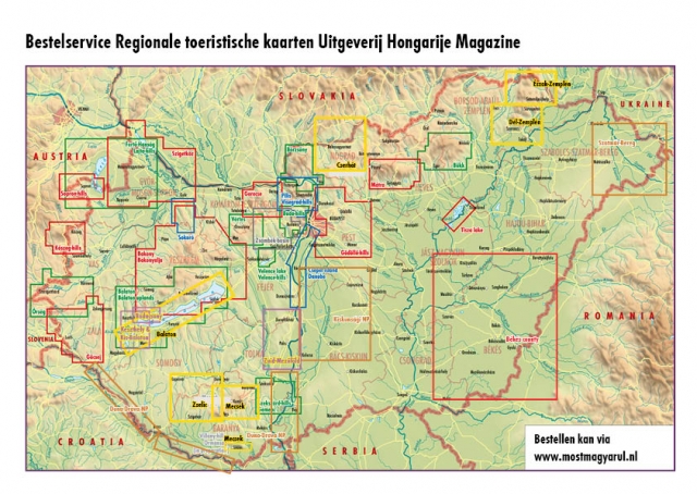
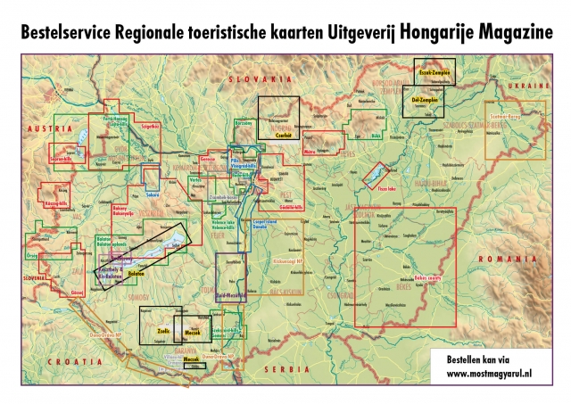
In onderstaand kaartje is te zien welke kaarten op dit moment leverbaar zijn. Op aanvraag kunnen wij ook andere regionale kaarten leveren. Prijs: 10,- per stuk (ex. portokosten), kleine kaartjes 5,-. U kunt bestellen via tel. 023 023 538 9461 of via het webformulier.